

HYDROLOGY
Genesis of Savery Pond
Savery Pond is a shallow "kettle pond" formed at the end of the last ice age, when a remnant block of glacial ice melted away, leaving a cavity in the surrounding glacial sediments that filled in with groundwater. Kettle ponds often form "closed depressions", but Savery Pond has an outflow stream that connects to the Ellisville Marsh Estuary ("Herring Brook").

Formation of Kettle Pond
The Pond as a Groundwater Feature
The pond surface is an expression of the local "groundwater table", and the pond is spring fed by the water-table aquifer. Groundwater in the Ellisville area is flowing towards Cape Cod Bay, so groundwater is expected to enter the pond on the inland (western) side and exit on the marine (eastern) side.
SPC has measured groundwater levels in local wells and mapped groundwater flow directions in the pond vicinity, as documented in our hydrology report. We have sampled groundwater in wells on the upgradient (inland) side of the pond, and found no evidence of elevated nutrient concentrations (i.e. nitrogen and phosphorus). Our groundwater mapping is useful for assessing subsurface transport of nutrients derived from septic systems into the pond.
A good summary of the interconnection between groundwater and surface-water can be found here.
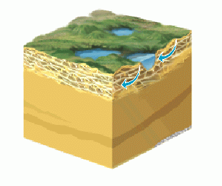
Groundwater Passing Thru a Pond
(Courtesy of U.S. Geological Survey)
Pond Water Budget
SPC performed a bathymetric survey to map the depth and volume of the pond. The 28-acre pond is relatively shallow, with an average depth of 6.5 feet, a maximum depth of 12.5 feet, and a stored volume of 181 acre-feet (58 million gallons). This may seem like a lot of water, but the Town of Plymouth uses this quantity in around 10 days! Water flowing through the pond flushes the stored volume, carrying various concentrations of nutrients with it. A "water budget" attempts to quantify the pond inflows (via groundwater, precipitation, and runoff from surrounding properties) and pond outflows (via groundwater and Herring Brook). SPC acquired equipment to measure pond outflow in Herring Brook, and monitoring (since May 2018) has shown baseflows ranging from 0.2 to 1.3 cubic feet per second (cfs). We have integrated our streamflow monitoring data with precipitation, groundwater and pond-level data in our hydrology report.
Developing a water budget for the pond, combined with understanding the nutrient concentrations of inflows and outflows, supports development of a nutrient budget and (ultimately) a nutrient management plan. Most important is how the rate of clean-water flushing compares to the rate of nutrients entering the pond. More information about nutrients in Savery Pond can be found here.

Elements of a Pond Water Budget
(Courtesy of U.S. Geological Survey)